

Blog 56: Best 3 European Vacation Destinations!
Welcome back to Brooke in the Air! This week, continuing with the European theme, we’re examining the best European vacation spots anyone can afford! In order of the top 3 cities on the continent, excluding locations in Russia for obvious reasons. This list eas going to be more exhaustive but frankly, I ran out of time. These are solely European destinations. I will do Asian, Oceanic, Canadian, South, Central American, Caribbean, and North American destinations another time, don’t you worry.
None of these are in a particular rank as they are all in the top of listed “must-sees.”
——————————————————
1. FRANKFURT-AM-MAIN, GERMANY
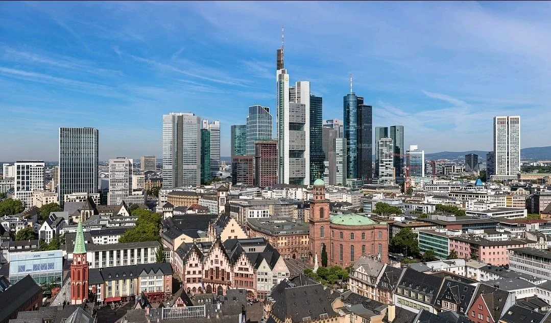
Panoramic of downtown Frankfurt contrasting the Old Town (AltStaat) and the new metropolis
Frankfurt-am-main is the most populous city and metropolis in the German Federal state of Hesse. Its 791,000 inhabitants as of 2022 make it the fifth-most populous city in Germany, and it is the only city in the country rated as an "alpha world city.” Located in the foreland of the Taunus on its namesake Main River, it forms a continuous conurbation with the neighboring city of Offenbach-am-Main and its urban area has a population of over 2.3 million. The city is the heart of the larger Rhine-Main metropolitan region, which has a population of more than 5.8 million and is Germany's second-largest metropolitan region after the Rhine-Ruhr region. Frankfurt's central business district lies about 90 km (or 56 mi) northwest of the geographic center of the EU at Gadheim in Lower Franconia. Frankfurt is the largest financial hub in continental Europe. It is home to the European Central Bank, Deutsche Bundesbank, Frankfurt Stock Exchange and several large commercial banks.
The Frankfurt Stock Exchange is one of the world's largest stock exchanges by market capitalization and accounts for more than 90 percent of the turnover in the German market.
In 2010, 63 national and 152 international banks had their registered offices in Frankfurt, including Germany's major banks, notably Deutsche Bank, DZ Bank, KfW and Commerzbank, as well as 41 representative offices of international banks.
NOTED LANDMARKS
Römer, the German word for Roman, is a complex of nine houses that form the Frankfurt city hall (or Rathaus). The houses were acquired by the city council in 1405 from a wealthy merchant family. The middle house became the city hall and was later connected with its neighbors. The Kaisersaal ("Emperor's Hall") is located on the upper floor and is where the newly crowned emperors held their banquets. The Römer was partially destroyed in World War II and later rebuilt. The surrounding square, the Römerberg, is named after the city hall. The former Altstadt (old town) quarter between the Römer and the Frankfurt Cathedral was redeveloped as the Dom-Römer Quarter from 2012 to 2018, including 15 reconstructions of historical buildings that were destroyed during World War II.
Frankfurt Cathedral

Top of the Frankfurt Cathedral
Frankfurt Cathedral (Frankfurter Dom) is not a cathedral, but the main Catholic church, dedicated to St. Bartholomew. The Gothic building was constructed in the 14th and 15th centuries on the foundation of an earlier church from the Merovingian time. From 1356 onwards, kings of the Holy Roman Empire were elected in this church, and from 1562 to 1792, Roman-German emperors were crowned there.
Since the 18th century, St. Bartholomew's has been called Dom, although it was never a bishop's seat. In 1867 it was destroyed by fire and rebuilt in its present style. It was again partially destroyed in World War II and rebuilt in the 1950s. Its height is 95 meters. The cathedral tower has a viewing platform open to the public at a height of 66 meters, accessed through a narrow spiral staircase with 386 steps.
St. Paul's Church
St. Paul's Church (Paulskirche) is a national historic monument in Germany because it was the seat of the first democratically elected parliament in 1848. It was established in 1789 as a Protestant church, but was not completed until 1833. Its importance has its roots in the Frankfurt Parliament, which met in the church during the revolutionary years of 1848/49 in order to write a constitution for a united Germany. The attempt failed because the monarchs of Prussia and Austria did not want to lose power. In 1849, Prussian troops ended the democratic experiment by force and the parliament dissolved; the building was once more used for religious services.
St. Paul's was, like many monuments, at least partially destroyed in World War II, particularly its interior, which now has a modern appearance. It was quickly and symbolically rebuilt after the war; today it is used mainly for exhibitions and events.
Archäologischer Garten Frankfurt
The Archaeological Garden contains small parts of the oldest recovered buildings: an ancient Roman settlement and the Frankfurt Royal Palace (Kaiserpfalz Frankfurt) from the sixth century. The garden is located between the Römerberg and the cathedral. It was discovered after World War II when the area was heavily bombed and later partly rebuilt. The remains were preserved and are now open to the public. From 2013 until 2015 an event building, the Stadthaus ("City house"), has been built on top of the garden, but it remains open to the public free of charge.
Haus Wertheim
Wertheim House is the only timbered house in the Altstadt district that survived the heavy bombings of World War II undamaged. It is located on the Römerberg next to the Historical Museum.
Saalhof
The Saalhof is the oldest conserved building in the Altstadt district and dates to the 12th century. It was used as an exhibition hall by Dutch clothiers when trade fairs were held during the 14th and 15th centuries. The Saalhof was partly destroyed in World War II and later rebuilt. Today it serves as a part of the Historical Museum.
Eiserner Steg

Eiserner Steg (Iron Bridge) in Frankfurt
The Eiserner Steg (Iron Bridge) is a pedestrian-only bridge across the Main that connects Römerberg and Sachsenhausen. It was built in 1868 and was the second bridge to cross the river. After World War II, when it was blown up by the Wehrmacht, it was quickly rebuilt in 1946. Today some 10,000 people cross the bridge on a daily basis.
And we have the museumsufer!

Stadel on the Museumsufer in Frankfurt-am-Main

Liebieghaus Museum on the Museumsufer in Frankfurt-am-Main
Der Museumsufer (the Museum Embankment) is the name of a landscape of museums in Frankfurt, lined up on both banks of the river Main or in close vicinity. The centre is the historic art museum Städel. The other museums were added, partly by transforming historic villas, partly by building new museums, in the 1980s by cultural politician Hilmar Hoffmann. The exhibition hall Portikus was opened on an island at the Alte Brücke in 2006.
As of 2023, 39 museums belong to the Museumsufer exclusively.
———————————————————
2. VENICE, ITALY

One of the famous canals in Venice, Italy (the Grand Canal) near the Piaza de San Marco leading into the Venetian Lagoon
In 2020, around 258,685 people resided in greater Venice or the Comune di Venezia, of whom around 51,000 live in the historical island city of Venice (centro storico) and the rest on the mainland (terraferma). Together with the cities of Padua and Treviso, Venice is included in the Padua-Treviso-Venice Metropolitan Area (abbreviated as PATREVE), which is considered a statistical metropolitan area, with a total population of 2.6 million.
The name is derived from the ancient Veneti people who inhabited the region by the 10th century BC. The city was historically the capital of the Republic of Venice for almost a millennium, from 810 to 1797. It was a major financial and maritime power during the Middle Ages and Renaissance, and a staging area for the Crusades and the Battle of Lepanto, as well as an important centre of commerce—especially silk, grain, and spice, and of art from the 13th century to the end of the 17th. The city-state of Venice is considered to have been the first real international financial centre, emerging in the 9th century and reaching its greatest prominence in the 14th century. This made Venice a wealthy city throughout most of its history. For centuries Venice possessed numerous territories along the Adriatic Sea and within the Italian peninsula, leaving a significant impact on the architecture and culture that can still be seen today. The sovereignty of Venice came to an end in 1797, at the hands of Napoleon. Subsequently, in 1866, the city became part of the Kingdom of Italy.
Venice has been known as "La Dominante", "La Serenissima", "Queen of the Adriatic", "City of Water", "City of Masks", "City of Bridges", "The Floating City", and "City of Canals". The lagoon and the historic parts of the city within the lagoon were inscribed as a UNESCO World Heritage Site in 1987, covering an area of 70,176.4 hectares (173,410 acres). In view of the fact that Venice and its lagoon are under constant threat in terms of their ecology and the safeguarding of the cultural heritage, Venice's UNESCO listing has been under constant examination by UNESCO. Parts of Venice are renowned for the beauty of their settings, their architecture, and artwork. Venice is known for several important artistic movements—especially during the Renaissance period—and has played an important role in the history of instrumental and operatic music; it is the birthplace of Baroque composers Tomaso Albinoni and Antonio Vivaldi.
In the 21st century, Venice remains a very popular tourist destination, a major cultural centre, and has been ranked many times the most beautiful city in the world. It has been described by The Times as one of Europe's most romantic cities and by The New York Times as "undoubtedly the most beautiful city built by man".
———————————————————
3. ISTANBUL, TURKEY

Panoramic still of Istanbul, Turkey, taken from the Bosporus.
OVERVIEW
AND GEOGRAPHY
I'm taking my time with Istanbul, forgive me, its a city near and dear to my heart. Formerly known as Constantinople before the Ottoman conquest, Istanbul is the largest city in Turkey, serving as the country's economic, cultural and historic hub. The city straddles the Bosporus strait, lying in both Europe and Asia, and has a population of over 15 million residents, comprising 19% of the population of Turkey.
ETYMOLOGY
The city was founded as Byzantium (Greek: Byzantiun) in the 7th century BCE by Greek settlers from Megara. In 330 CE, the Roman emperor Constantine the Great made it his imperial capital, renaming it first as New Rome (Latin: Nova Roma) and then as Constantinople (Constantinopolis) after himself. In 1930, the city's name was officially changed to Istanbul, the Turkish rendering of the romanized: eis tḕn Pólin; or 'to the City', i.e. the appellation which Greek speakers used since the 11th century to colloquially refer to the city.

Istanbul viewed from its Asian side, note the Hagia Sophia in the distance.
The city served as an imperial capital for almost 1600 years: during the Roman/Byzantine (330–1204), Latin (1204–1261), late Byzantine (1261–1453), and Ottoman (1453–1922) empires. The city grew in size and influence, eventually becoming a beacon of the Silk Road and one of the most important cities in history. The city played a key role in the advancement of Christianity during Roman/Byzantine times, hosting four of the first seven ecumenical councils before its transformation to an Islamic stronghold following the Fall of Constantinople in 1453 CE—especially after becoming the seat of the Ottoman Caliphate in 1517. In 1923, after the Turkish War of Independence, Ankara replaced the city as the capital of the newly formed Republic of Turkey.

The great mosque of the Hagia Sophia
Over 13.4 million foreign visitors came to Istanbul in 2019, eight years after it was named a European Capital of Culture, making it the world's eighth most visited city. The historic center of Istanbul is a UNESCO World Heritage Site.
FASCINATING HISTORY
Constantinople (Istanbul) is generally considered to be the center and the "cradle of Orthodox Christian civilization".
Constantinople began to decline continuously after the end of the reign of Basil II in 1025. The Fourth Crusade was diverted from its purpose in 1204, and the city was sacked and pillaged by the crusaders. They established the Latin Empire in place of the Orthodox Byzantine Empire. Hagia Sophia was converted to a Catholic church in 1204 CE. The Byzantine Empire was restored, albeit weakened, in 1261 CE. Constantinople's churches, defenses, and basic services were in disrepair, and its population had dwindled to a hundred thousand from half a million during the 8th century.
On the 29th of May in 1453 CE, after an eight-week siege (during which the last Roman emperor, Constantine XI, was killed), Sultan Mehmed II "the Conqueror" captured Constantinople and declared it the new capital of the Ottoman Empire. Hours later, the sultan rode to the Hagia Sophia and summoned an imam to proclaim the Islamic creed, converting the grand cathedral into an imperial mosque (see above) due to the city's refusal to surrender peacefully. Mehmed declared himself as the new Kayser-i Rûm (the Ottoman Turkish equivalent of the Caesar of Rome) and the Ottoman state was reorganized into an empire. Thus, the Ottoman Empire was formally born.
Following the conquest of Constantinople, Mehmed II immediately set out to revitalize the city. Cognizant that revitalization would fail without the repopulation of the city, Mehmed II welcomed everyone–foreigners, criminals, and runaways– showing extraordinary openness and willingness to incorporate outsiders that came to define Ottoman political culture. He also invited people from all over Europe to his capital, creating a cosmopolitan society that persisted through much of the Ottoman period. Revitalizing Istanbul also required a massive program of restorations, of everything from roads to aqueducts. Like many monarchs before and since, Mehmed II transformed Istanbul's urban landscape with wholesale redevelopment of the city center. There was a huge new palace to rival, if not overshadow, the old one, a new covered market (still standing as the Grand Bazaar), porticoes, pavilions, walkways, as well as more than a dozen new mosques. Mehmed II turned the ramshackle old town into something that looked like an imperial capital.
MODERN HISTORY
The Ottoman Dynasty claimed the status of caliphate in 1517, with Constantinople remaining the capital of this last caliphate for four centuries. Suleiman the Magnificent's reign from 1520 to 1566 was a period of especially great artistic and architectural achievement; chief architect Mimar Sinan designed several iconic buildings in the city, while Ottoman arts of ceramics, stained glass, calligraphy, and miniature flourished. The population of Constantinople was 570,000 by the end of the 18th century, the dawn of the Napoleonic Era.
Sultan Abdul Hamid II was deposed with the Young Turk Revolution in 1908 and the Ottoman Parliament, closed since 14 February 1878, was reopened 30 years later on 23 July 1908, which marked the beginning of the Second Constitutional Era. A series of wars in the early 20th century, such as the Italo-Turkish War (1911–1912) and the Balkan Wars (1912–1913), plagued the ailing empire's capital and resulted in the 1913 Ottoman coup d'état, which brought the regime of the Three Pashas.

Istanbul from the Bosporus Bridge
The Ottoman Empire joined World War I (1914–1918) on the side of the Central Powers and was ultimately defeated. The deportation of Armenian intellectuals on 24 April 1915 was among the major events which marked the start of the Armenian genocide during WWI. Due to Ottoman and Turkish policies of so-called “Turkification” and ethnic cleansing, the city's Christian population declined from 450,000 to 240,000 between 1914 and 1927.
The Allies occupied Constantinople on 13 November 1918. The Ottoman Parliament was dissolved by the Allies on 11 April 1920 and the Ottoman delegation led by Damat Ferid Pasha was forced to sign the Treaty of Sèvres on 10 August 1920. The Ottoman version the Treaty of Versailles.
Following the Turkish War of Independence (1919–1922), the Grand National Assembly of Turkey in Ankara abolished the Sultanate on 1 November 1922, and the last Ottoman Sultan, Mehmed VI, was declared persona non grata. Leaving aboard the British warship HMS Malaya on 17th of November 1922, he went into exile and died in Sanremo, Italy, on 16th of May 1926. The Treaty of Lausanne was signed on 24th of July in 1923, and the occupation of Constantinople ended with the departure of the last forces of the Allies from the city on 4th of October in 1923. Turkish forces of the Ankara government, commanded by Şükrü Naili Pasha (3rd Corps), entered the city with a ceremony on 6th of October 1923, which has been marked as the Liberation Day of Istanbul (Turkish: İstanbul'un Kurtuluşu) and is commemorated every year on its anniversary.

Modern Istanbul’s Financial District from the air above the Istanbul Sapphire
On 29 October 1923 the Grand National Assembly of Turkey declared the establishment of the Turkish Republic, with Ankara as its capital. Mustafa Kemal Atatürk became the Republic's first President.
Dolmabahçe Palace, the seat of government during the late Ottoman period, is in the Beşiktaş district on the European shore of the Bosporus strait, to the north of Beyoğlu. The former village of Ortaköy is within Beşiktaş and gives its name to the Ortaköy Mosque on the Bosporus, near the Bosporus Bridge. Lining both the European and Asian shores of the Bosporus are the historic yalıs, luxurious chalet mansions built by Ottoman aristocrats and elites as summer homes. Inland, north of Taksim Square is the Istanbul Central Business District, a set of corridors lined with office buildings, residential towers, shopping centers, and university campuses. Maslak, Levent, and Bomonti are important nodes within the Istanbul CBD.
A CITY FOR HISTORY LOVERS
There are traces of the Byzantine era throughout the city, from ancient churches that were built over early Christian meeting places like the Hagia Irene, the Chora Church, the Monastery of Stoudios, the Church of Sts. Sergius and Bacchus, the Church of Theotokos Pammakaristos, the Monastery of the Pantocrator, the Monastery of Christ Pantepoptes, the Hagia Theodosia, the Church of Theotokos Kyriotissa, the Monastery of Constantine Lips, the Church of Myrelaion, the Hagios Theodoros, etc.; to palaces like the Great Palace of Constantinople and its Mosaic Museum, the Palace of the Porphyrogenitus, Boukoleon Palace and Palace of Blachernae; and other public places and buildings like the Hippodrome, the Augustaion, the Basilica Cistern, Theodosius Cistern, Cistern of Philoxenos and Cistern of the Hebdomon, the Aqueduct of Valens, the Prison of Anemas, the Walls of Constantinople and the Porta Aurea (Golden Gate), among numerous others. The 4th century Harbor of Theodosius in Yenikapı, once the busiest port in Constantinople, was among the numerous archeological discoveries that took place during the excavations of the Marmaray tunnel. I could go on for ages.
————————————————————
4. SANTORINI, GREECE

Santorini on a photo brochure
Santorini, officially Thera, or Thira in classical Greek, an island in the southern Aegean Sea, about 200 km (or 120 mi) southeast from the Greek mainland. It is the largest island of a small circular archipelago, which bears the same name and is the remnant of a caldera. It forms the southernmost member of the Cyclades group of islands, with an area of approximately 73 km2 (or a total of 28 sq mi) and a 2011 census population of 15,550. The municipality of Santorini includes the inhabited islands of Santorini and Therasia, as well as the uninhabited islands of Nea Kameni, Palaia Kameni, Aspronisi and Christiana.
ETYMOLOGY & BACKGROUND

Photo Presentation of the Theotokos church, Pyrgos village, Santorini
Santorini was named by the Latin Empire in the thirteenth century, and is a reference to Saint Irene, from the name of the old cathedral in the village of Perissa – the name Santorini is a contraction of the name Santa Irini. Before then, it was known as Kallístē (Καλλίστη, "the most beautiful one"), Strongýlē (Στρογγύλη, "the circular one"), or Thēra. The name Thera was revived in the nineteenth century as the official name of the island and its main city, but the colloquial name Santorini is still in popular use. Thera is the ancient name and it was called this because of Theras, the leader of the Spartans who colonized it, and gave his name to the island, a common practice for conquerors within and outside of Greece. The oldest signs of human settlement are Late Neolithic (4th millennium BC or earlier), but c. 2000–1650 BC Akrotiri developed into one of the Aegean's major Bronze Age ports, with recovered objects that came not just from Crete, but also from Anatolia, Cyprus, Syria, and Egypt, as well as from the Dodecanese and the Greek mainland.
Probably after what is called the Bronze Age collapse, Phoenicians founded a site on Thera. Herodotus reports that they called the island Callista and lived on it for eight generations. In the ninth century BC, Dorians founded the main Hellenic city on Mesa Vouno, 396 m (1,299 ft) above sea level. This group later claimed that they had named the city and the island after their leader, Theras. Today, that city is referred to as Ancient Thera.
In his Argonautica, written in Hellenistic Egypt in the third century BC, Apollonius Rhodius includes an origin and sovereignty myth of Thera being given by Triton in Libya to the Greek Argonaut Euphemus, son of Poseidon, in the form of a clod of dirt. After carrying the dirt next to his heart for several days, Euphemus dreamt that he nursed the dirt with milk from his breast, and that the dirt turned into a beautiful woman with whom he had sex. The woman then told him that she was a daughter of Triton named Calliste, and that when he threw the dirt into the sea it would grow into an island for his descendants to live on. The poem goes on to claim that the island was named Thera after Euphemus' descendant Theras, son of Autesion, the leader of a group of refugee settlers from Lemnos.
As with other Greek territories, Thera then was ruled by the Romans. When the Roman Empire was divided, the island passed to the eastern side of the Empire which today is known as the Byzantine Empire. According to George Cedrenus, the volcano erupted again in the summer of 727, the tenth year of the reign of Leo III the Isaurian. He writes: "In the same year, in the summer, a vapour like an oven's fire boiled up for days out of the middle of the islands of Thera and Therasia from the depths of the sea, and the whole place burned like fire, little by little thickening and turning to stone, and the air seemed to be a fiery torch." This terrifying explosion was interpreted as a divine omen against the worship of religious icons and gave the Emperor Leo III the Isaurian the justification he needed to begin implementing his Iconoclasm policy.
The name "Santorini" first appears c. 1153-1154 CE in the work of the Muslim geographer al-Idrisi, as "Santurin", from the island's patron saint, Saint Irene. After the Fourth Crusade, it was occupied by the Duchy of Naxos which held it up to circa 1280 when it was reconquered by Licario (the claims of earlier historians that the island had been held by Jacopo I Barozzi and his son as a fief have been refuted in the second half of the twentieth century); it was again reconquered from the Byzantines circa 1301 by Iacopo II Barozzi, a member of the Cretan branch of the Venetian Barozzi family, whose descendant held it until it was annexed in c. 1335 by Niccolo Sanudo after various legal and military conflicts. In 1318–1331 and 1345–1360 it was raided by the Turkish principalities of Menteshe and Aydın, but did not suffer much damage. Because of the Venetians the island became home to a sizable Catholic community and is still the seat of a Catholic bishopric.
In general the island's economy continued to decline following World War II with a number of factories closing as a lot of industrial activity relocated after to Athens. In an attempt to improve the local economy the Union of Santorini Cooperatives was established 1947 to process, export and promote the islands agriculture products, in particular its wine. In 1952 they constructed near the village of Monolithos what is today the island's only remaining tomato processing factory. The island's tourism in the early 1950s generally took the form of small numbers of wealthy tourists on yacht cruises though the Aegean. The island's children would present arriving passengers with flowers and bid them happy sailing by lighting small lanterns along the steps from Fira down to the port, offering them a beautiful farewell spectacle. Once such visitor was the actress Olivia de Havilland who visited the island in September 1955.
TOURIST INDUSTRY

Pyrgos Kallistis village on Santorini
The expansion of tourism in recent years has resulted in the growth of the economy and population. Santorini was ranked the world's top island by many magazines and travel sites, including the Travel+Leisure Magazine, the BBC, as well as the US News media An estimated 2 million tourists visit annually. In recent years, Santorini has been emphasising sustainable development and the promotion of special forms of tourism, the organization of major events such as conferences and sport activities.
The island's pumice quarries have been closed since 1986, in order to preserve the caldera. In 2007, the cruise ship MS Sea Diamond ran aground and sank inside the caldera. As of 2019, Santorini is a particular draw for Asian couples who come to Santorini to have pre-wedding photos taken against the backdrop of the island's landscape.
THANK YOU FOR JOINING ME ON BROOKE IN THE AIR THIS WEEK! PLEASE REMEMBER TO LIKE, COMMENT, AND SUBSCRIBE TO NY YOUTUBE CHANNEL AND JOIN MY PATREON FOR ADDITIONAL CONTENT 💖💖